Pixel Watch 5 GPS Accuracy Tested Against Apple and Garmin on the London Marathon Course

Testing Google Pixel Watch 5 GPS Accuracy: How Server-Side AI and Mapping Data Perform Against Garmin and Apple
When smartwatch manufacturers make bold claims about hardware and software capabilities, testing those assertions under challenging real-world conditions reveals whether marketing promises translate into meaningful performance gains. Google made a direct claim with the launch of the Pixel Watch 5: its updated GPS system achieves superior route-tracking accuracy compared to established industry leaders, explicitly naming the Apple Watch Ultra 3 and the Garmin Fenix 8 Pro as benchmarks it could surpass.
For runners, hikers, and urban endurance athletes, satellite location precision is more than a technical specification. GPS fidelity dictates distance logging, pace calculations, and navigation reliability. To evaluate Google’s claims, a head-to-head field test was conducted across one of the most notoriously difficult satellite testing environments: miles 18 through 20 of the London Marathon route, winding through the Isle of Dogs and Canary Wharf. This area is packed with towering steel and glass skyscrapers that frequently disrupt satellite signals, making it an ideal testing ground for high-end wearables.
The Engineering Behind Google’s GPS Redesign
To understand how the Pixel Watch 5 claims an edge over dedicated multi-sport wearables, it helps to examine its technical architecture. Like the Garmin Fenix 8 Pro and Apple Watch Ultra 3, the Pixel Watch 5 uses dual-band GPS. This setup allows the watch to communicate simultaneously across two distinct radio frequencies (L1 and L5) with global satellite constellations, helping reduce location errors caused by signal reflections off high-rise buildings, dense tree cover, or atmospheric interference.
Hardware, however, is only part of Google’s approach. The Pixel Watch 5 combines dual-band satellite reception with software innovations and off-device processing:
- Google Maps 3D Structural Integration: Google utilizes its extensive repository of 3D building data from Google Maps alongside machine learning models. By predicting how radio signals bounce off specific skyscraper geometries—a phenomenon known as multipath interference—the software can correct for distorted location coordinates.
- Global Reference Station Calibration: The tracking system incorporates data from ground-based GPS reference stations placed globally to offset signal delays caused by atmospheric conditions.
- Off-Device Server Processing: Continuous high-precision GPS signal processing demands significant power, which can quickly drain a wearable battery. Google addresses this by compressing raw satellite data directly on the device during a workout. Once the activity is saved, the compressed file is transmitted to cloud servers, where advanced correction algorithms refine the route before syncing the finalized track to the Google Health app.
Field Testing in Canary Wharf’s Urban Canyon
Evaluating GPS accuracy requires pushing receivers into environments where satellite line-of-sight is severely obstructed. The test route covered miles 18 through 20 of the London Marathon course and ran in reverse for a total distance of 5 kilometers per leg. The path traversed narrow streets, glass-walled plazas, and structural overhangs near Heron Quays, Bank Street, Trafalgar Way, and Poplar.
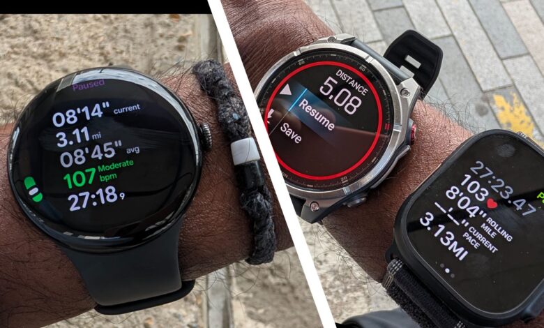
To isolate signal reception performance and eliminate physical bias, watch placement was swapped between wrists across two distinct test runs. All three smartwatches recorded activities using their native workout applications. Post-run track files were exported—including converting the Pixel Watch 5’s native TCX output to GPX format—and uploaded into spatial analysis software using tools like IloveGPX for direct route overlays.
Observed Route Alignment and Spatial Fidelity
Along open stretches near Billingsgate Market, all three devices maintained aligned tracks. However, as the course entered the dense skyscraper cluster of Canary Wharf, structural reflection caused clear differences in performance across the devices.
The Garmin Fenix 8 Pro experienced noticeable track drift when navigating deep urban canyons. Its location line drifted off actual running paths onto adjacent buildings, resulting in an over-calculated total distance by approximately 0.2 miles (0.3 km) over a 5km distance, alongside a slower reported average speed.
The Apple Watch Ultra 3 demonstrated strong signal retention, holding close to the physical running line throughout the course with minimal trajectory deviation, closely matching the actual distance covered.
The Pixel Watch 5 delivered surprising path fidelity, recording the cleanest visual route through the tallest high-rise sectors. Even when taking intentional off-route loops through high-reflection zones around Bank Street and Heron Quays, its server-corrected track maintained tight alignment with actual footpaths without displaying the wide lateral jumps often seen in urban smartwatch tracking.
Side-by-Side Performance Comparison
| Parameter / Metric | Google Pixel Watch 5 | Apple Watch Ultra 3 | Garmin Fenix 8 Pro |
|---|---|---|---|
| GPS Architecture | Dual-band GPS with server-side AI processing | Dual-band GPS with on-device algorithmic modeling | Dual-band multi-constellation GPS |
| Signal Correction Method | Google Maps 3D building data and global reference stations | Multi-frequency signal filtering and sensor fusion | Multi-band satellite selection and point-smoothing |
| Data Processing Location | Compressed locally; processed on external cloud servers | On-device real-time processing | On-device real-time processing |
| Urban Canyon Route Fidelity | Strongest line retention; minimal building drift | High accuracy; minor tracking variance near skyscrapers | Noticeable track drift; veered onto structural obstacles |
| Distance Measurement Consistency | Consistent with Apple Watch Ultra 3 baseline | Closest alignment with target distance route | Over-measured distance by ~0.2 mi / 0.3 km |
| Real-Time Pacing Stability | Fluctuated early in runs; occasional post-run pace spikes | Moderate early variance; steady after initial signal lock | Inconsistent pace feedback in degraded signal zones |
Pacing Data Realities: Route Lines vs. Live Metrics
While visual GPX tracks evaluate spatial accuracy, real-time pacing responsiveness is equally vital for competitive runners. During race conditions, imprecise live pacing data can cause an athlete to misjudge effort levels, running either too fast or too slow if reported speeds jump erratically due to degraded satellite reception.
During field tests, all three devices encountered challenges providing consistent real-time pacing data within dense skyscraper corridors. The Pixel Watch 5 struggled to establish stable live pacing metrics during the initial minutes of a workout before settling into accurate ranges. Additionally, post-run activity summaries within the Google Health app occasionally displayed brief, unnaturally fast pacing spikes that did not reflect actual running effort.
This reveals a key trade-off in Google’s cloud-assisted tracking framework:
- Post-Processed Precision vs. Real-Time Latency: Offloading raw GPS data for server-side processing produces exceptionally clean post-run route maps. However, because heavy path-correction occurs after data reaches the cloud, it provides limited benefit for live, on-wrist pacing adjustments during an active run.
- Battery Efficiency: Compressing satellite data on the watch rather than executing intensive processing locally helps preserve wearable battery life, making it a clever compromise for slim general-purpose smartwatches.
Practical Takeaways for Runners and Outdoor Navigators
Google’s claims regarding the Pixel Watch 5’s GPS capabilities are largely validated by real-world testing in demanding conditions. By leveraging 3D building mapping, global reference points, and server-side machine learning, the Pixel Watch 5 successfully mitigates much of the spatial drift that traditionally affects wearables in dense urban environments.
For outdoor enthusiasts, trail hikers, and runners who prioritize accurate route logging and clean post-workout maps, Google’s architectural shift represents a genuine step forward in smartwatch navigation technology. However, for marathon runners who rely heavily on precise, lag-free pacing feedback during a race, real-time metrics still require software tuning. Nevertheless, Google’s integration of cloud intelligence with dual-band wearable hardware proves that smartwatches can deliver high-level GPS route tracking in the most challenging environments.