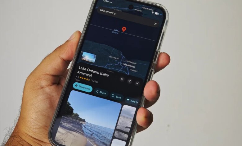
Google Maps Updates Lake Ontario to ‘Lake America’ for US Users Following Executive Order
Users in the United States opening Google Maps to view the Great Lakes will notice a significant change along the northern border. Lake Ontario, one of the five major North American Great Lakes, is now labeled as “Lake America” for visitors accessing the platform within the United States. The mapping update follows an executive order issued by President Donald Trump, which led the United States Geographic Names Information System (GNIS) to formally alter the domestic naming entry for the body of water.
Google confirmed that the change reflects its long-established policy of aligning mapped geographic labels with official database records maintained by domestic government authorities. However, because the lake forms a key segment of the international boundary between the United States and Canada, the platform has implemented a localized display approach rather than a universal rebrand across its global service.
How Geolocation Determines What Map Users See
The implementation of the new name varies depending on the physical location or regional configuration of the person accessing Google Maps. Because Canada has not altered its official terminology, the mapping platform serves different versions of the same geographic region based on user location.
For individuals accessing the service within the United States, the app displays “Lake America.” Across the international border, Canadian users looking at the identical body of water continue to see its historical name, “Lake Ontario.” For the rest of the world operating outside both nations, Google Maps displays a dual designation combining both titles: “Lake Ontario (Lake America).”
This localized approach allows Google to remain compliant with domestic government standards without imposing one country’s domestic legal decisions onto another sovereign nation’s digital infrastructure.
A Repeat Pattern: Following the Gulf of Mexico Precedent
This update is not the first time Google Maps has deployed a multi-version geographic display in response to changes in United States federal naming conventions. A near-identical scenario unfolded in early 2025 regarding the Gulf of Mexico.
Following a federal designation change that renamed the body of water to the “Gulf of America” within official United States domestic databases, Google applied the same algorithmic policy. American map users were presented with “Gulf of America,” while users in Mexico retained the designation “Gulf of Mexico.” International users outside those two jurisdictions were presented with a dual label displaying both names concurrently.
The framework highlights how tech platforms navigate disputed, dual-named, or politically sensitive geographic features across international boundaries. Rather than acting as an independent arbiter of global cartography, Google relies on authoritative national mapping bodies—such as the GNIS in the United States—to supply the baseline text rendered within specific territorial borders.
Comparing Regional Display Standards on Digital Maps
The practical result of Google’s policy is that digital maps are no longer uniform globally. The table below illustrates how geographic labels vary based on the user’s geographic location for recent United States domestic naming changes.
| Geographic Feature | United States Users | Bordering Nation Users | International Users |
|---|---|---|---|
| Lake Ontario / Lake America | Lake America | Lake Ontario (Canada) | Lake Ontario (Lake America) |
| Gulf of Mexico / Gulf of America | Gulf of America | Gulf of Mexico (Mexico) | Gulf of Mexico (Gulf of America) |
The Cartographic Shift from Static Paper to Dynamic Feeds
Historically, paper maps provided a singular, fixed view of the world, printed and distributed with standardized labels agreed upon by specific cartographic publishers. Digital navigation platforms have fundamentally changed this dynamic by making maps responsive, fluid, and context-dependent.
Modern mapping services rely on continuous data integration from sovereign government databases. When a national government updates its domestic geographic names registry, digital platforms can propagate those updates quickly through automated software updates. However, when those updates involve shared natural borders—such as lakes, rivers, ocean gulfs, or mountain ranges—the automated system encounters conflicting official sources.
To resolve these conflicts, mapping software uses IP address detection and device account settings to serve localized geographic data feeds. While this prevents technological conflict with domestic regulators, it also creates a situation where two people standing on opposite sides of a border river or lake looking at the same map application see different place names for the exact same location.
Sovereignty and the Limits of Domestic Naming Policies
The official designation shift inside the United States highlights the boundaries of domestic legal authority over shared international geography. While a domestic executive order and subsequent updates to the Geographic Names Information System mandate how federal agencies and domestic platforms label features within the United States, they do not carry force of law in neighboring sovereign nations.
Canadian territorial waters cover a substantial portion of Lake Ontario’s surface area, and Canadian provincial and federal authorities retain sole jurisdiction over official placenames within their territory. Because Canada continues to recognize the historical name, international mapping standards outside the United States reflect either the established name or a combined hybrid format.
For businesses, shipping logistics operators, international travelers, and everyday consumers, this split presentation represents a practical shift in how digital geography operates. Cross-border communications, environmental reporting, and regional mapping will require awareness that map labels are increasingly custom-tailored to the viewer’s physical location.
What Readers Should Understand
The update to Lake Ontario within Google Maps illustrates a broader trend in how digital platforms handle international geography. Rather than serving as a single, objective record of world geography, modern navigation software operates as a localized service that adapts to the legal demands of local governments.
While users inside the United States will now routinely see “Lake America” on their devices, the international consensus surrounding the lake’s designation remains divided along diplomatic boundaries, leaving global audiences with a hybrid map designed to accommodate both realities.